


Strings
String data hierarchy
- points
- segments
- strings
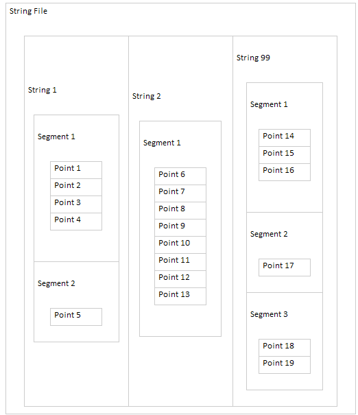
The example below shows conceptually how a string file contains strings, which contain segments, which contain points.
Types of strings
There are three types of strings:
- open
- closed
- spot height
The table below explains these terms.
| Surpac term | Common term | Example |
|---|---|---|
|
Open string |
Line |
Drill hole trace |
|
Closed string |
Polygon |
Property boundary |
|
Spot height string |
Points not associated with a line or polygon |
Blast hole collar locations |
Description fields
Points, strings, and segments can have one or more pieces of descriptive information associated with them. This information is stored in a description field. Description fields are named according to the order they appear. Description fields are named in the format D<incremental number>, such as D1, D2, D3.
For example, a closed segment representing an ore zone could have the gold grade, silver grade, and specific gravity stored in separate description fields. If the information is stored in that order, they could be assigned as follows:
D1: gold grade
D2: silver grade
D3: specific gravity
Data numbering
Strings, segments, and points are identified by unique numbers. You can assign string numbers to represent particular features, such as string 1 for toes in a pit, string 2 for crests, and string 99 for spot heights. Surpac automatically assigns segment numbers and point numbers.
Data ranges
You can use a range to refer to groups of data numbers, such as strings, segments, and points.
The comma ( , ) is used for a range that includes a start, an end, and, optionally, an increment. You use the following format to specify such a range in Surpac:
<start>,<end>,<increment>
 Note: When the increment is 1, you can use <start>,<end> without specifying the increment.
The semicolon ( ; ) is used to identify unique values, or to separate multiple ranges.
Here are some examples:
|
Data values |
Range |
Description |
|---|---|---|
|
1 2 3 4 5 6 7 8 |
1,8 |
from 1 to 8, at an increment of 1 (implied) |
|
1 3 5 7 |
1,7,2 |
from 1 to 7, at an increment of 2 |
|
2000 2200 2400 |
2000,2400,200 |
from 2000 to 2400, at an increment of 200 |
|
1 6 |
1;6 |
1 and 6 |
|
2 6 9 |
2;6;9 |
2 and 6 and 9 |
|
2 3 4 5 6 9 |
2,6;9 |
from 2 to 6 at an increment of 1 (implied) and 9 |
|
25 50 60 70 80 90 |
25;50,90,10 |
25 and from 50 to 90 at an increment of 10 |
|
3 6 9 12 15 20 30 |
3,15,3;20;30 |
from 3 to 15, at an increment of 3 and 20 and 30 |
|
5 10 15 20 40 50 60 |
5,20,5;40,60,10 |
from 5 to 20, at an increment of 5 and from 40 to 60, at an increment of 10 |
String file names
Surpac string file names have the following components:
| Component | Description | Required? |
|---|---|---|
|
Location |
Any combination of characters and numbers |
Required |
|
ID |
Numbers only |
Optional |
|
Extension |
Always .str |
Required |
Here are some examples of file names:
|
File name |
Location |
ID |
Extension |
|---|---|---|---|
|
pit.str |
pit |
|
.str |
|
bench105.str |
bench |
105 |
.str |
|
2007design.str |
2007design |
|
.str |
|
2007design2.str |
2007design |
2 |
.str |
|
grade_control135.str |
grade_control |
135 |
.str |
|
dhcomp2_50.str |
dhcomp2_ |
50 |
.str |
|
level-300.str |
level |
-300 |
.str |
Spaces in file names are not recommended. In some situations, Surpac might not work correctly if you are using a file that has a space in the file name.
You can use ranges to refer to the ID of filenames. For example, you can refer to the files:
geo130.str, geo140.str, geo150.str, geo160.str, geo170.str
using the following syntax:
Location: geo ID: 130,170,10
String directions
- Clockwise strings represent an area of inclusion.
- Anticlockwise strings represent an area of exclusion.
Viewing string data
Here is an example that demonstrates the previous concepts.
Task: View string data
- Click Reset graphics
 .
. - Open bench105.str in Graphics.
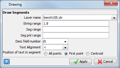
- Choose Display > Strings > With string and segment numbers.
- Enter the information as shown, and click Apply.
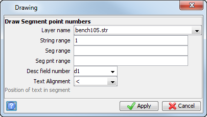
- Choose Display > Point > Numbers.
- Enter a value of 1 for the String range, and click Apply.
- Click Reset graphics .
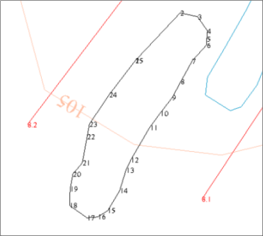
The file bench105.str is displayed.
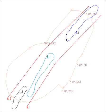
The data in this file represents a horizontal view, also known as a plan view, of a pit design, the survey stations, and the geology for one level in a pit.
The data is organised as follows.
|
String number |
Segment number |
Data |
Type |
D1 |
D2 |
D3 |
|---|---|---|---|---|---|---|
|
1 |
1 |
Low grade ore |
Closed |
Gold (g/t) |
Silver (g/t) |
SG |
|
2 |
1 |
Medium grade ore |
Closed |
Gold (g/t) |
Silver (g/t) |
SG |
|
3 |
1 |
High grade ore |
Closed |
Gold (g/t) |
Silver (g/t) |
SG |
|
8 |
1 |
Footwall trace |
Open |
footwall |
|
|
|
8 |
2 |
Hangingwall trace |
Open |
hangingwall |
|
|
|
30005 |
30005 |
Pit design toe |
Closed |
|
|
|
|
30008 |
30008 |
Survey stations |
Spot height |
Station name |
|
|
The order of points for string 1 is clockwise in the XY plane.
Note: To see all the steps performed in this task, run 01a_viewing_string_data.tcl. You need to click Apply on any forms presented.
String file structure
Sometimes it is helpful to view the contents of a string file in a text editor.
Task: View string data in a text editor
- From the Navigator, right-click bench105.str, and select Edit.
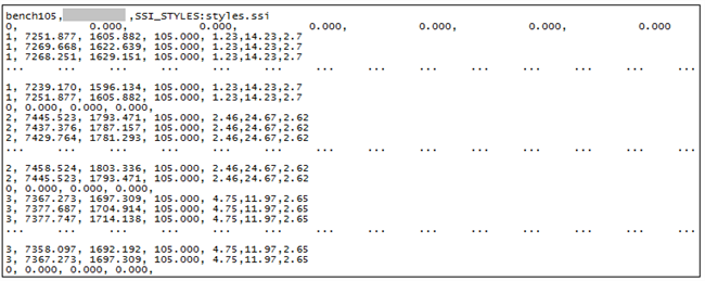
- The first line is known as the header record, and contains these items: file name, date modified, purpose (which is empty in this example), styles file.
- The second line contains the axis record. This is a two-point line used in some sectioning functions. For many string files this is not required; when it is not required, values of zero are used for all coordinates. The Y, X, and Z values of each of the two end points of the axis are stored in the following order: Y(1), X(1), Z(1), Y(2), X(2), Z(2).
- The third line is the start of string data, and is stored as String number, Y, X, Z, D1, D2, D3, … D100.
- A null record indicates the end of a segment.
- String 1 is closed, because the first point and the last point are the same.
- When the file was created, the following values were chosen: D1 = gold (g/t), D2 = silver (g/t), and D3 = SG. String 1 outlines an area of low grade ore with:
- a gold value of 1.23 grams/tonne.
- a silver value of 14.23 grams/tonne.
- a specific gravity of 2.7.
- Scroll down in the file to see the data as shown.
The file opens in your text editor.
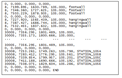
- String 8 is open, since the first and last points are different.
- String 8 consists of two segments.
- String 30005 is closed, since the first and last points are the same.
- String 30008 is a spot height string with the survey station name in the D1 field.
- Exit the text editor without saving any changes.
Note: Manually editing string files is not recommended. If the format becomes corrupt, Surpac may not work correctly when using the file.