Geological database concepts
You use the Geological Database module in Surpac when you are conducting feasibility studies, or want to perform estimations from drillhole data.
A geological database consists of a number of tables, each of which contains different types of data. Each table contains a number of fields. Each table also has many records, with each record containing the data fields.
Surpac uses a relational database model and supports several types of databases, including Oracle, Paradox, and Microsoft Access. Surpac also supports Open Database Connectivity (ODBC) and can connect to databases across networks. A database can contain up to 50 tables and each table can have a maximum of 60 fields.
Surpac requires two mandatory tables within a database: collar and survey.
Collar table
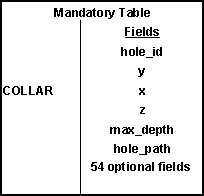
The information stored in the collar table describes the location of the drill hole collar, the maximum depth of the hole, and whether a linear or curved hole trace will be calculated when retrieving the hole. Optional collar data can also be stored for each drill hole. For example, date drilled, type of drill hole, or project name.
The mandatory fields in a collar table are shown as follows:
Survey table
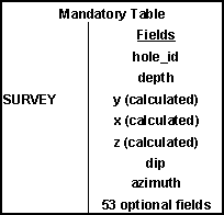
The survey table stores the drill hole survey information used to calculate the drill hole trace coordinates. Mandatory fields include downhole survey depth, dip, and azimuth of the hole.
For a vertical hole that has not been surveyed, the depth would be the same as the max_depth field in the collar table, the dip would be -90, and the azimuth would be zero.
The y, x, and z fields are used to store the calculated coordinates of each survey.
Optional fields for this table can include other information taken at the survey point. For example, core orientation.
The mandatory fields in a survey table are:
Optional tables
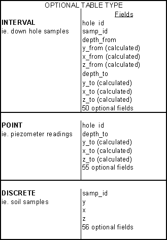
As well as the mandatory tables, optional tables can be added and used to store information, such as geology and assays.
There are three different types of optional tables that can be added to a database:
- Interval (depth from and depth to)
- Point (depth to)
- Discrete (point data)
Interval tables require the depth at the start of the interval (depth_from)and the depth at the end of the interval (depth_to).
Point tables require only the depth at which the sample was taken (depth _to). A sample identifier field is defined for interval tables but it is not a key field. This means it does not require data, the field can be left empty if there is no data available. The y, x, and z fields are used to store the calculated coordinates of the sample depths.
Discrete sample tables are used for storing data for a point, which has a unique samp_id. All that is required for this table is the samp_id and its position in space. That is, its y, x, and z coordinates. The discrete sample table is ideally suited for storing and later processing geochemical soil samples.
The following diagram is a summary of the data that can be contained in the optional tables: