


Stope Profile
This function computes the profile of a stope, and applies the method of end areas to determine its volume.
To run this function: Choose Survey > Underground surveys > Stope profile, or...
 Note: STOPE PROFILE will automatically correct for input strings that cross, so that no string
preprocessing is necessary.
Note: STOPE PROFILE will automatically correct for input strings that cross, so that no string
preprocessing is necessary.
Define the stope survey string file
Enter the Location, ID number, and String Range of the file containing the stope profile strings.
Choose Apply to display the DEFINE AN AXIS LINE FORM.
The DEFINE AN AXIS LINE FORM defines the extent of the stope in the direction of the axis.
Note: Best results are obtained if the axis is defined graphically. See Axis Graphics.
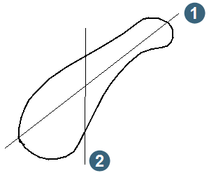
|
1. best axis 2. inappropriate axis |
Complete the DEFINE AN AXIS LINE form and choose Apply to display the RANGE OF SECTIONS AND OUTPUT form.
Extent of Data.
Display only. These coordinates indicate the extent of the data in the direction of the axis line.
Define Range of Sections.
Enter the range of the sections in ascending order along the axis. For example, 6700,6900,5 means that you require sections every 5 meters from 6700 to 6900,. If the axis is skewed, the range end of the axis is always at zero.
Define the Output File for Sections.
Enter the Location and ID number of a string file in which the output sections can be stored.
Result
The function will produce a .not file with the Location and ID Number of the output file. This file contains the details of the volume calculations on a section by section basis.