


Wild T2000/Husky Data Recorder
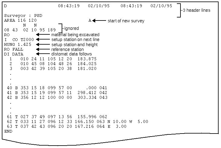
The data format for the T2000-Husky data recorder is described here. Click here for details on the processing of data recorder files.
This Total Station and field computer combination has been developed by Taylor Woodrow in the United Kingdom.
From the Survey menu, select Data recorders, then T2000-Husky to invoke the function.
Features NOT SUPPORTED by the T2000/Husky data recorder include:
- Down load and upload functions
- Date values are not obtained from the data recorder
- Time values are not obtained from the data recorder
- Temperature values are not obtained from the data recorder
- Pressure values are not obtained from the data recorder
- Co-ordinate values are not obtained from the data recorder
The restrictive format of this data collector does not permit the coding of string numbers with any freedom and so the strings created are determined by a single character code which is described below.
The distomat data records consist of a number of fields. These are:
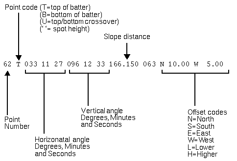
Point Codes
String numbers are assigned to surveyed points as shown in the table below:
| Point Code | String number |
|---|---|
| ` ' | 1 - used for spot heights |
| T | 2 - used for tops of batters |
| B | 3 - used for bottoms of batters |
| U | The point exists at a crossover of Top and Bottom of a batter. The string number is changed from 2 to 3 or 3 to 2 and the point is saved to both strings. |
Offset Codes
Offset codes may exist in the right most fields of the observation record. These offset codes consist of an offset code and an offset amount. The coordinates of the point are first calculated without consideration to the offset codes and then the offsets are applied to shift the point to the required position.
| Offset Code | Result |
|---|---|
| N | Shift the point to the North by the offset amount. |
| S | Shift the point to the South by the offset amount. |
| E | Shift the point to the East by the offset amount. |
| W | Shift the point to the West by the offset amount. |
| L | Decrease the elevation of the point by the offset amount. |
| H | Increase the elevation of the point by the offset amount. |