Strings from centroids
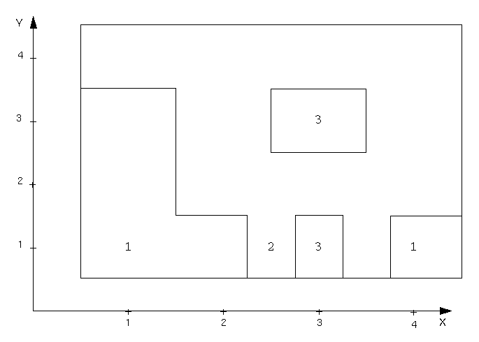
The STRINGS FROM CENTROIDS function takes point data which lie on a grid, or an approximate grid, and converts it into 'string blocks' which may be processed by other modules.
The function accepts as input, layers of point data. The data may be block centroid data (on a regular grid), as from a block model, or from flitch data extracted from a drill hole database, which in the general case consists of 'nominal section lines' along which holes may occur at fixed or variable intervals.
Each data point is enclosed by a rectangular block string which is assigned a grade associated with that data point. In this way, layers of data which together comprise an orebody model may quickly be generated.
To run this function: Choose File tools > Create polygons from centroids, or...
Define the Input Files Containing Centroids
Enter the Location and ID Range of the file(s) containing the input point data.
Keep Descriptions?
Enter 'Y' to retain the description field(s) in the output string files and 'N' to remove the descriptions.
Range of Section Lines
It is preferable for the point data to be regularly spaced in at least one direction. This question asks for the range of regular lines in the data along nominal Y coordinates, usually Northings. All data, if irregularly spaced, are assumed to lie along the nearest of these lines.
Define the Output Files Containing Strings
Enter the Location which is to used for the range of files which are to contain the generated block strings. One file will be created corresponding to each points file layer.
Limits of Influence of Each Sample
Max. X Influence (+/-)
Max. Y Influence (+/-)
Within the point data, the rule for formation of blocks surrounding individual points is that block boundaries are formed midway between section lines, and midway between neighbouring points along that line.
In the case of irregularly spaced lines or points, or missing data, it is often desirable to limit the influence of a particular data point in both directions. This input gives the limits of influence in both directions around the point.
Consolidate Blocks?
The data input to this program often contain a large number of points, and the resulting blocks will contain five times that number of data points unless consolidation of adjoining blocks occur.
Consolidation implies that all neighbouring blocks of the same string are joined together to produce a single block, hence reducing the total number of points.
If you choose to retain the descriptions then all description fields of the consolidated blocks are amalgamated to give an area weighted average of the component blocks.
Should you wish to consolidate blocks and your data have a number of grade ranges, you must first classify your point data in STRING TOOLS Classify Strings.
Note: There is no restriction applied to the values in the description fields so that regardless of how much these values differ by, they will nevertheless be combined.
A warning message is displayed in the message window if a non-numeric field (i.e. text) is encountered in a description field. The non-numeric field will be treated as zero.
The formation of block strings from point data is carried out in several stages depending on the options you have selected. Assuming that you have chosen to retain the description fields and to consolidate blocks then the processing is as follows.
Sorting
Firstly, the points in each input file are grouped into the various sections specified then sorted into order of increasing easting.
You are informed that the sorting is being carried out by the message
Sorting ...which will appear in the message window.
Grade Amalgamation
This stage will ensure all neighbouring points of the same string number have the same area weighted average grades in each description field. That is, if your strings contain one description field then this single value is averaged but if there are five description fields then all five are individually averaged and the original value replaced by this newly calculated one.
Amalgamating grades ...is displayed in the message window when this stage of the processing is being performed.
String Formation
You will see the message
Generating blocks ...in the message window when the point data are ready to be transformed into block strings. Using the position of the surrounding points, the specified X and Y influences and the distance between the previous and next section lines the dimensions of the block can be calculated. String formation follows on from the amalgamation process whereby all the adjoining points collected above are converted into strings.
String Consolidation
To consolidate the strings, all intersecting or overlapping edges found in the generated strings are removed to produce a single closed segment. There may, of course, be several closed segments for each string as not all points for each string will necessarily be along side each other.
You will notice the message
Consolidating blocks ...in the message window when this final stage is reached.
The above steps are then repeated for every string in each layer.
Consider a simple set of point data thus, with the points indicated with a 'x' and the string number above and to the right.
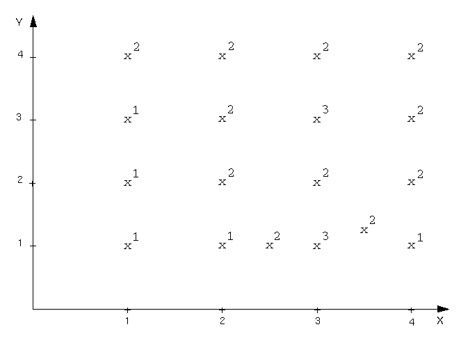
Notice all points are regularly spaced except those along the bottom row.
Range of Section Lines = 1,4
Max. X Influence (+/-) = 0.5
Max. Y Influence (+/-) = 0.5
Consolidate Blocks? = 'N'
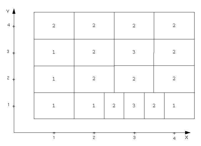
Range of Section Lines = 1,4
Max. X Influence (+/-) = 0.5
Max. Y Influence (+/-) = 0.5
Consolidate Blocks? = 'Y'