Open file containing existing design
You can use this function to load one or more string or DTM files into Graphics. When you use this function, instead of dragging a file into Graphics, you can choose to retain the existing view in Graphics, so any 3D rotation and zooming that you have done is not changed.
To run this function: Choose Design > Road design > Design horizontal inflection points > Open file containing existing design, or
Fields on the Recall a file form
| Field | Description |
|---|---|
| Layer | The layer to load the data into: either an existing layer or a new layer. |
| Location | The name of the file to load into Graphics. |
| ID range |
The ID Range of the file or files to load into Graphics.
|
| Data loading options | |
| File type | DTM or string. If you choose DTM, the string file of the same name is also loaded. |
| String range | If you selected File type: String, String range is the range of strings to display. |
| Load data with |
|
| Drawing styles file | The drawing styles file to use to display string data. If you do not specify a Drawing styles file, the default drawing styles file is used, which is specified in the draw styles file setting in defaults.ssi. |
| Retain descriptions |
|
| Rescale display |
|
 Tip: If you have named a series of files the same except for the numeric ID, and then specify the range of IDs in the
  Caution: If you clear
 Output
The string or DTM data you chose is displayed in Graphics.
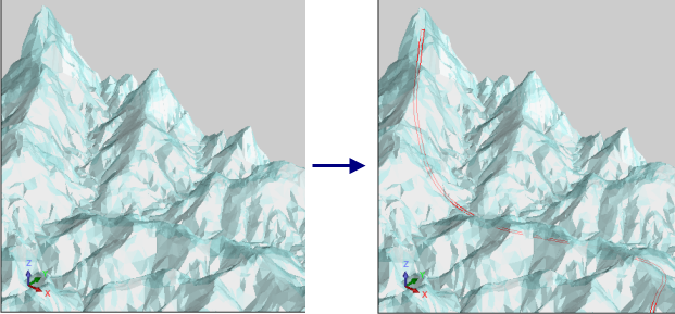
The following image shows an example where topography is displayed with 40% transparency, and rotated and zoomed to a specific view. Then a final road outline is loaded to Graphics with Rescale display cleared.